I’m just back from the fabled Vuelta al Cotopaxi. Ok, so it wasn’t the official mountain biking race that’s encircles Ecuador’s most famous volcano, but a similar route of our own doing. Here’s a first round of photos – more on this bikepacking adventure soon…
Onward plans are now almost fully formed, though typically subject to change… I’ll be heading south from here, looping round to Lago Quilatoa, before picking up some dirt roads to Baños. From there, I’ll backtrack to Ambato, and follow a trail that wends its way between the twin volcanoes of Chimborazo and Carihuairazo, down to Riobamba. Then, I have a choice. Cut down to Macas in the Amazon basin lowlands, or stay up high towards Cuenca and pick my way down a dirt road further to the south. Once in the Amazonas, it’s a paved road to Loja, then more dirt into the mountains to Zumba, on the Peruvian border…
Summer seems to be coming to Ecuador, so I’m hopeful for some dry days!

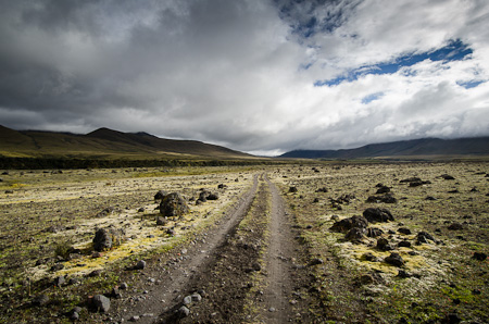
After a high traverse from Pintag, we approached mighty Cotopaxi – one of highest active volcanoes in the world – on this wisp of a jeep track.

Cotopaxi the following morning, under clear skies.

The remote jeep track that leads to the lone hacienda at el Tambo, 3700m, on the eastern side of the volcano – by now lost behind a thick halo of cloud.

Ecuadorian farmers on their way up into the páramo, the treeless, barren, high altitude plains typical of Ecuador.

This ‘road’ barrelled us down from our highest pass, 4200m; hopschotching ruts and watersnakes was the name of the game.

Thankfully, my Ecuadorian riding companion, Michael, shared a love of exploring each and every singletrack opportunity that came our way…


Enjoy Quilatoa…I have fond memories of the cobbles and the Black Sheep Inn. We went over the top of the hill behind the inn to a section of pristine cloud forest…awesome epiphytic orchids and bromeliads.
Me too (fond memories) – would be keen to know if you can cycle the singletrack around Quilatoa …and those cobbles…but that’s nothing new to you! Black Sheep inn too , won awards for it’s truly eco-approach. Lots a nice pueblitos chiquititos !
I will keep an eye out for quality flora and think of you!
Did you hike Cotopaxi? So crazy to feel the effects of the altitude.
No… That would be cool though. You?
More brilliant photos and travel log from the intrepid single track explorer… you ARE amazing… especially LOVED the photo depicting those Ecuadorian farmers riding up the páramo, over those barren plains. Stunning simplicity… take care in that altitude and watch for the bandits… X
Great photos. That’s it, I’m clicking on the “Follow” button.