The AZT Chain Gang - Welsh, English and soon-to-be Canadian.
Here’s some more pictures from the AZT – you can find the first batch over here. They’re in no particular order I’m afraid. Anyone planning a similar ride will have to wait for Cen to update his blog with a more thorough report, along with info and stats gleaned from the GPS – though I’ll try and add in more details as I remember them.
I rode the portion between Flagstaff and Nogales, along with Rocket Scott, Cen and Nerys, who’d already ridden down from the Utah border. Then I returned to Flagstaff to ride solo some of what I’d missed – more on that later. I’ll try and post some details of the kit we were carrying too.
First things first though. For those who haven’t heard about the AZT, it’s an 800 mile multi-use trail, a blend of singletrack and dirt roads developed and maintained by volunteers, running from Arizona’s border with Utah, all the way down to Mexico. En route, it passes through the Grand Canyon (bikes have to be shouldered and hiked, or shuttled round), as well as national forests, lakes, deserts and groves of enormous, spiney cacti. The official hiking AZT also traverses a series of Wilderness Areas but these are closed to bikers; these can generally be diverted round on dirt tracks.
Although it is, in theory, a multi-use trail, large parts of the journey are definitely hard work on a bicycle; extended pushes through sandy washes, hard fought battles with flesh-piercing thorn bushes, and hike ‘n bikes across loose, bouldery gullies that may well – just for the rarest, briefest of moments – challenge your concept of what’s enjoyable on a bike. Plus, there’s the added element that water points are few and far between, particularly over late summer, the time of year we rode it.
Quite apart from the slow going progress of riding so much singletrack, this in itself can dictate how you break up the ride. We left camp in the morning with five litres each in bottles and bladders; or ten litres on the odd occasion we were expecting a dry camp. Thanks to all the astute planning and research from tripmaesters Scott and Cen, it all worked out really well. Only once did we suffer a particularly parched night, where I had to eek out half a litre of water over the evening and morning. During a fitful sleep, I dreamt vivid, water-themed dreams… Few people have yet to through-ride the entire route unsupported – maybe just ten – so there’s not too much info online. Those who have, tend to start in the spring, alleviating some of the water carrying issues.
Bear in mind too that although much of the AZT is rideable in some form or other, it still needs a good deal of work to make it more bike friendly – which is understandable, given that it’s only just been completed and is maintained purely by volunteers. Eventually, a set of bike-specific maps suggesting diversions to the more extreme hike ‘n bike sections and detours around the Wilderness Area would be handy – similar to those on the Great Divide. As it is, we downloaded the excellent route notes suggested by Scott Morris and fed them into the GPS – a must for navigating the unmarked desert trails.
But don’t let all this put you off. The AZT is an incredible experience and I can only see it getting better and better as it becomes more established. It’s definitely a sizeable notch up in terms of challenges compared to touring the longer Great Divide Mountain Bike Ride, and one I’d really recommend to anyone who wants to blend lightweight touring with some amazing mountain biking…

Out in the heat and thornbush corridors south of Tucson.

Cen swoops round through some sublime singletrack on the mesa above Flagstaff.

Although Arizona is associated with parched desert and cacti, much of the northern section of the ride meanders in and out of shaded pine forests.

Amongst a particularly gruelling hike 'n bike along the Highline Trail ('maintained' by the girl scouts, as the signboard proudly proclaimed), a couple of brief but beautiful, redrock riding sections offered respite.

Ace framebag builder Scott is in the business of storage, albeit it of the ultralight variety. Here he is with full kit loaded up on his Rick Hunter 29er. He decked out all with our bikes with similar custom framebags, helping us to ride technical terrain without the clutter and weight of panniers.

One of the many unrideable slogs along the pipeline track to Oracle. This one went on for miles. Up and down. Up and down…

More of those wonderful, fingery saguaro cacti. Each one really seemed to have its own character.

The thorns we had to contend with. We ran a mixture of tubeless tyres and slime-filled inner tubes, so actually suffered very few punctures.

Our bikes were as light as we could run them, making the odd fence crossing a whole lot easier than it would be with panniers or a trailer. The 'bikepacking' framebag setup is definitely the way to go for this ride.

Hitching passage on Scott’s monster wheel.

We didn’t see this perfectly camouflaged rattlesnake until we almost trod on it, at which point it started shaking its rattle furiously. Scott lobbed a stone in its direction to move it on, accidentally hitting it on the bonce – driving it into further apoplexy.

Gentle folds in the mountains near Mount Lemmon, in the beautiful Santa Catalina Mountains. Here began a 5000ft climb.

And the fun, slickrock-style technical descent from Summerhaven to the massive urban sprawl of Tuscon on the other side.

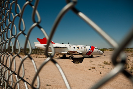
Tuscon is home to a large airforce base, and tankbusters regularly screeched overhead. While there, I cycled round the fenceline of the ‘Boneyard’. Thousands of decommissioned military planes stretch for mile after mile into the desert, in perfect symmetry. It was a eery place; despite the billions of wasted war dollars, there was a strange sense of geometrical beauty to the place.

Far from home. A retired US Coast Guard plane, perfectly preserved in the dry Tuscon air.

The nearby Pima Air and Space Museum was home to the likes of this Mach 3 Lockheed Blackbird, dating back to the late 60s.

As well as squadrons of fighter jets, set dramatically against the burnt blue sky with their inscect-like proboscis.

Massive, ominous-looking bombers, dwarfing all those around them.

And these goofy looking helicopters.

A world apart from all this military hardware, lay the liberal, hippy settlement of Patagonia, 18 miles from border with Mexico. Still a long way from its namesake in Argentina though…

This is the peaceful, grassy courtyard around its impressive library. Although we all carried handheld email-gathering devices, I took advantage of the many small libraries in settlements we rode through – which also sold second hand books for less than a dollar.

Behind this fence lay a clutter of motorbikes and bicycles. America is full of junk of all shapes and sizes.

Arizona isn’t just deserts… This is the calm, clear water of Theodore Roosevelt Lake.

My fascination for US gas guzzlers continues…

Apache Canyon, where we stopped for a refreshing swim.

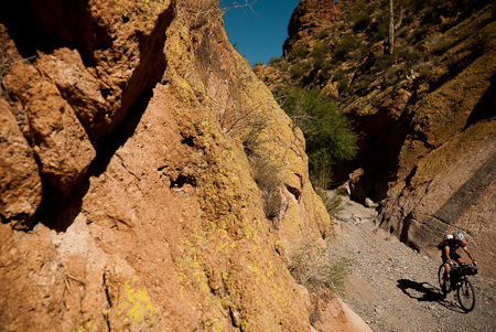
Riding the 'wash' down the tight and narrow Box Canyon.

South of Colossal Cave. That day we rode some 30 miles of sweet singletrack.

Art deco store fronts along Superior's main drag. Despite its diminutive size and ghost town feel, it was one of my favourite resting spots on the ride.

Superior’s saloon. Cowboy hats and bicycle helmets welcome.

Arizona's trademark crisp, golden light coats the Superstition Mountains, just a few miles from the stripmall sprawl of Apache Junction.

Riding dirt roads out of Payson to skirt round one of the Wilderness Areas closed to bikers.

Although most of the AZT is on dirt roads and singletrack, bikers will need to cover some stretches along paved highways too. Most have a generous shoulder.

A freight train passes overhead, breaking the silence of the desert as it clatters endlessly by.

Sonoita, a cowboy community en route to Nogales, on the Mexican border.

There, we briefly left the desert to cross a swathe of prairieland and cattle ranches.

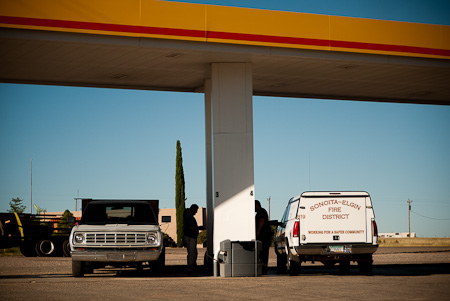
Rush hour in this tiny junction settlement.

Tasty. Chewy beef jerky, that omnipresent American snack, which we mixed in with dehydrated soups…

Late afternoon. Road riding to Patagonia. Just a day left until we reached the border.

Nogales USA (left side) and Nogales Mexico (right side). Never the two shall meet…

Adios AZT crew!


Nice writeup,
Glad you having fun riding 29″-ers in ultralight style;) I wish I could do it in Tibet like that… Haha…
Rich
PS: Can’t wait to get home from Thailand. I have a bike in a box waiting for me and didn’t have chance to put it together before I left. I won it last year over @ mtbcast.com: another 29″, Siren’s John Henry. Woohoo;)
BTW, Cass, do you have any idea when, more or less, you’ll be hitting Altiplano salt flats in Bolivia??? Not trying to distract you from your Arizona fun;)
Yes, I heard about that windfall! Nice! Still on the Fargo though? That ti model looks good too…
Aiming for Bolivia in june/july next year, which will hopefully give me some time to do stop, explore and work along the way…
can you get mum to bring me back some beef jerky? coooooooool. it’s actually yum. far superior to fish crisps. and super expensive here.
xx
Hi Cass,
I used one photo of Scott from this post on my blog to give his business a plug. Let me know if that’s cool..if not I can pull that photo. It’s credited to you and I linked back to your blog.
http://thelazyrando.wordpress.com/2010/11/23/porcelain-rocket/
Safe riding,
Vik
http://www.thelazyrando.com
No probs Vic. I’m a big fan of your site!